↓
 
Ashland Hiking Group 
 
  • About Us
  • Posted Hikes
    • Recent
    • Monday
    • Wednesday
    • Friday
    • Friday Flower
  • Hike Schedules
    • Monday
      • Current
      • Previous
    • Wednesday
      • Current
      • Previous
    • Friday
      • Current
      • Previous
    • Friday Flower
      • Current
      • Previous
  • Locations
    • Lakes
      • Applegate Lake
      • Azalea Lake
      • Castle Lake
      • Crater Lake
      • Duck Lakes
      • East Boulder Lake
      • Emigrant Lake
      • Fish Lake
      • Kangaroo Lake
      • Lost Creek Lake
      • Mountain Lakes
      • Puck Lakes
      • Seven Lakes
      • Sky Lakes
      • Smith Lake
      • Squaw Lakes
      • Taylor Lake
    • PCT
      • Brown Mountain
      • Castle Crags
      • Cement Bluff
      • Etna Summit
      • Greensprings Area
      • Gumboot Boulder
      • Hyatt/Greensprings Summit
      • Hyatt Reservoir
      • Mt Ashland Area
      • Pilot Rock Area
      • Porcupine Lake
      • Red Buttes
    • Rivers & Streams
      • Elk Creek
      • Frog Pond
      • Kelsey Creek
      • Lower Rogue
      • Mill Creek Falls
      • Sacramento River
      • Squaw Valley Creek
      • Upper Rogue
      • Taylor Creek
    • Snow Shoes
      • Buck Prairie
      • Crater Lake
      • Deadwood
      • Great Meadow
      • Grouse Gap
      • Hyatt Lake
      • Moon Prairie
      • Mt Ashland
      • Mt Shasta
      • Pederson
      • Pilot Rock
      • Summit Sno-Park
    • Mountains & Summits
      • A>L
        • Abbot Butte
        • Anderson Butte
        • Arch Rock
        • Baldy Peak
        • Big Red Mountain
        • Bolt Mountain
        • Castle Crags
        • Collings Mountain
        • Frank Hill Road
        • Grayback Mountain
        • Grizzly Peak
        • Kerby Peak
      • M>Z
        • Mount Ashland
        • Mount Bailey
        • Mount Eddy
        • Mount Elijah
        • Mount Shasta
        • Pompadour Bluff
        • Roxy Ann
        • Squaw Peak
        • Stein Butte
        • Stukel Mountain
        • Table Rocks
        • Union Peak
        • Wagner Butte
    • Woods
      • Ashland City
      • Ashland Watershed
      • Bear Creek Greenway
      • Cathedral Hills
      • Denman Wildlife Refuge
      • East Applegate Ridge
      • Enchanted Forest
      • Greenhorn Park
      • Greensprings Area
      • High Lakes Trail
      • Horseshoe Ranch
      • Jack Ash
      • Jacksonville
      • Layton Mine Ditch
      • Pacifica
      • Sterling Mine Ditch
      • Steves 40 Acres
    • Miscellaneous
  • Images
    • Resize @ 1000H ,1000V & med before uploading
  • Log In

Category Archives: Mt. Ashland Area

Post navigation

← Older posts
Newer posts →

Ski Road to Grouse Gap on Mt. Ashland

Ashland Hiking Group Posted on July 17, 2023 by Randy BryanApril 23, 2024

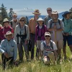
The attractions of cooler temperatures, special views of Mt Shasta on a clear day, and nature’s ample bounty in the meadows of Mt. Ashland brought out 20 Monday hikers to enjoy this local favorite hike out to the Grouse Gap … Continue reading →

Posted in Monday, Mt. Ashland Area, PCT

Post navigation

← Older posts
Newer posts →
©2025 - Ashland Hiking Group - Weaver Xtreme Theme
↑