↓
 
Ashland Hiking Group 
 
  • About Us
  • Posted Hikes
    • Recent
    • Monday
    • Wednesday
    • Friday
    • Friday Flower
  • Hike Schedules
    • Monday
      • Current
      • Previous
    • Wednesday
      • Current
      • Previous
    • Friday
      • Current
      • Previous
    • Friday Flower
      • Current
      • Previous
  • Locations
    • Lakes
      • Applegate Lake
      • Azalea Lake
      • Castle Lake
      • Crater Lake
      • Duck Lakes
      • East Boulder Lake
      • Emigrant Lake
      • Fish Lake
      • Kangaroo Lake
      • Lost Creek Lake
      • Mountain Lakes
      • Puck Lakes
      • Seven Lakes
      • Sky Lakes
      • Smith Lake
      • Squaw Lakes
      • Taylor Lake
    • PCT
      • Brown Mountain
      • Castle Crags
      • Cement Bluff
      • Etna Summit
      • Greensprings Area
      • Gumboot Boulder
      • Hyatt/Greensprings Summit
      • Hyatt Reservoir
      • Mt Ashland Area
      • Pilot Rock Area
      • Porcupine Lake
      • Red Buttes
    • Rivers & Streams
      • Elk Creek
      • Frog Pond
      • Kelsey Creek
      • Lower Rogue
      • Mill Creek Falls
      • Sacramento River
      • Squaw Valley Creek
      • Upper Rogue
      • Taylor Creek
    • Snow Shoes
      • Buck Prairie
      • Crater Lake
      • Deadwood
      • Great Meadow
      • Grouse Gap
      • Hyatt Lake
      • Moon Prairie
      • Mt Ashland
      • Mt Shasta
      • Pederson
      • Pilot Rock
      • Summit Sno-Park
    • Mountains & Summits
      • A>L
        • Abbot Butte
        • Anderson Butte
        • Arch Rock
        • Baldy Peak
        • Big Red Mountain
        • Bolt Mountain
        • Castle Crags
        • Collings Mountain
        • Frank Hill Road
        • Grayback Mountain
        • Grizzly Peak
        • Kerby Peak
      • M>Z
        • Mount Ashland
        • Mount Bailey
        • Mount Eddy
        • Mount Elijah
        • Mount Shasta
        • Pompadour Bluff
        • Roxy Ann
        • Squaw Peak
        • Stein Butte
        • Stukel Mountain
        • Table Rocks
        • Union Peak
        • Wagner Butte
    • Woods
      • Ashland City
      • Ashland Watershed
      • Bear Creek Greenway
      • Cathedral Hills
      • Denman Wildlife Refuge
      • East Applegate Ridge
      • Enchanted Forest
      • Greenhorn Park
      • Greensprings Area
      • High Lakes Trail
      • Horseshoe Ranch
      • Jack Ash
      • Jacksonville
      • Layton Mine Ditch
      • Pacifica
      • Sterling Mine Ditch
      • Steves 40 Acres
    • Miscellaneous
  • Images
    • Resize @ 1000H ,1000V & med before uploading
  • Log In

Category Archives: Frank Hill Road

Post navigation

← Older posts
Newer posts →

Frank Hill Road

Ashland Hiking Group Posted on February 27, 2023 by Randy BryanApril 23, 2024

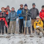
We had another good turn out Monday as 15 hikers gathered next to Liz’s house on Ashland Mines Road for a snow covered trek up Frank Hill Rosd. Many were doing this hike for the first time and Liz was … Continue reading →

Posted in Frank Hill Road, Monday, Mountains & Summits

Post navigation

← Older posts
Newer posts →
©2025 - Ashland Hiking Group - Weaver Xtreme Theme
↑